Tackless II's Home Page & Website
Women & Cruising Website
Jimmy Cornell's Noonsite
Seven Seas Cruising Association
Fiji's Weather Site Victoria University's S. Pacific Weather Site Fijian History Palmlea Lodge and Bures Nukubati Resort Musket Cove Vuda Point Marina First Landing Resort About Vanuatu About New Caledonia
25-29 September 2008 – Hunkered Down in Port Boisé
24-25 september 2008 -- A record for T2
19-24 September 2008 – Baie Doking, Lifou Island, ...
13-18 September 2008 – Ouvea
10-14 September 2008 – Taking the Rally to New Cal
6-10 September 2008 – Port Vila
19-23 August 2008 - Rom Festival on Ambrym
6 September 2008 – Laboring our Way to Efate
30 August 2008 – Banan Bay, Malekula
Baie de Prony is named for the vessel that first explored it in 1854. Only ten years later a "forestry industry" began here using convict labor. (New Caledonia was, like Australia, initially a penal colony.) Throughout the bay are sprinkled ruins of convict "settlements," but there are no remains of the forest. I've been told that the original forest cover was the huge, slow-growing kauri pine that was popular in shipbuilding. Not sure if this is correct. It is hard to imagine. There is none of it remaining, and no evidence of replanting. The hills as far as you can see are red earth, thinly covered by green scrub with great orange gashes of landslides and erosion. It is sad but oddly beautiful.
We were surprised that Procyon would take the very first anchorage because Baie de Prony has no fewer than 16 identified anchorages within it, six of which alone are in the large eastern interior bay called Bonne Anse. Anchorage "A", as it is dubbed in the cruising guide, is right out behind the wooded point that merges with Prony Reef and is only protected from southeasterly winds, which, granted, are the predominant winds in the region. Well, it proved to be an outstanding choice, because the wide open view to the west – over Prony Reef to Île Ouen and the Woodin Channel -- then north to the multicolored hills backing the western side of the Baie de Prony -- was simply awesome, morning, midday, evening and even by moonlight!
PROCYON REUNION
Randy and Sheri had, unfortunately, been forced to spend nearly a month in Noumea after Randy had a mishap learning to kite-board and rammed a piece of coral well up into his foot. This became quite infected and ended up needing surgery, and his back compounded his misery by going into spasms. He was not a happy camper for a few weeks. However, he had as good an experience with the French medical system in Noumea as we had in Raiatea, and, in the end, Noumea is not a bad place to recuperate with its delightful market right at the head of the marina. The good news for us is that the Procyons would otherwise have already been on their way to Australia, and now they will be making that trip the same time as we.
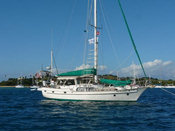
We had a lovely afternoon and evening visiting aboard Procyon, which is a custom-built Gozzard 44, a truly beautiful boat with an owner's open layout placing a spacious dining/living area in the triangular space where usually there would be a forepeak cabin. We did steaks and baked potatoes on the grill, and relished a green salad with fresh ingredients and talked boat talk around their lovely dining table. It was a fleeting reunion, though as early the following the morning, they were underway south to the Isle of Pines. We, however, were left with the gorgeous view to ourselves.
BONNE ANSE
We lingered there a day working on various projects, then the next morning raised anchor to poke around the other five anchorages in Bonne Anse. One of the reasons Randy and Sheri has stopped so quickly is that they had seen a number of boats precede them in this direction. Over the course of the following day, we'd watched most of them leave again, so when we motored east ourselves, we were pleased to see that all but one boat had departed. We chose anchorage "E" on the north side of the bay in which to put the hook down as the forecast was calling for the wind to clock around to the north. Anchorage "E" was a cove of eroded orange hills laced with green, a red sand beach backed by a grove of green trees, and a wide semi-circle of shoals completely sedimented in red silt. Grandterre's red and green color scheme, so eyecatching at a distance, is rather intense up close, and in anchorage "E" we had totally sacrificed the long view. It was, however, quite a bit warmer, a function, I think, of both the wind shift to the north and the encircling land mass. Plus, again, we were totally alone…that is, except for the flies.
We had heard mention of the fly problem on the radio but had not imagined its degree. We paid the price for being late getting our screens up as the interior of the boat was beseiged. We are talking hundreds. The flyswatter was excavated and put to constant use. There is one redeeming feature of flies; they go to sleep at night, so you can. Okay, and they don't bite. But, Jiminy Christmas they are IRRITATING!
Our second morning in Anchorage "E", we dinghied across the bay to a trailhead leading to the lighthouse atop Cap Ndoua. This is the very important leading light for the Havanna Passage, the main ship entry from the east. We secured the dinghy off a nice little red sand beach and easily found the trail. Once upon a time, this trail was a road, but erosion has carved deep gullies in the bed, and recent rains or perhaps just the morning dew made the hard-packed clay very slick. We emerged from the tunnel of trees about half-way up and climbed the rest of the way to the light flanked by hip-high brush but with awesome views in every direction. What's really amazing about this panorama is that there is hardly any sign of man in it, discounting the light itself and its associated equipment, some ruins on a lower plateau, and a couple of red earth roads winding off to the east. That the hike is a popular one is attested to by a "flagpole" where hikers have hung items of clothing (including a pair of bikini panties) as well as a curious form of natural graffiti: the entire vale just east of the light is filled with "signatures" shaped from assembled rocks and then framed in a rectangle of rocks. I suggested we put together a "Tackless II was here" or "The Two Captains were here", but Don pointed out that either would take a lot of rocks.
But here's a peculiar thing. No flies on shore!
The illusion of "little sign of man" proved to be just that: An illusion. As we motored out of Bonne Anse that afternoon to check out some of the anchorages on Prony's western side, a huge industrial complex was revealed filling up the whole eastern part of the bay! Just over the ridge from where we'd been anchored! Now we know that the great lume of light we'd been seeing in the sky since Port Boisé is not Noumea at all, but this plant! The cruising guide describes a rock crushing facility here, which it claims closed in 1968. Whatever this is, it is neither defunct nor old!
Once revealed, it tuned out to be pretty hard to shake the specter of that monstrosity. We motored behind a little resort island called Ilot Casy up into the western arm of the bay, but still bits of the factory kept sticking up above the landmasses we tried to put between us and it. We were intending to go all the way up the bay to its fjord-like end, an area known as Carenage, with two hurricane-hole anchorages and some hot springs. But Don's interest was waning fast, so we turned instead towards a cove called Anse Sebert. Imagine our surprise when we rounded the point and found not just four other boats (one of them our buddies on Avior), but moorings!
ANSE SEBERT
We aren't sure who put these moorings here, but there are about ten of them. The chart shows a village nearby, but Jim and Paula of Avior did a walk ashore and found only ruins amongst which there appeared to be holiday "shacks." So perhaps they are the work of a Noumea-based cruising club. However, the landing was not in the possession of vacationers today, but a squadron of military types with a small fleet of inflatables. Over the course of the afternoon, a helicopter landed, took off, circled and landed over and over, and guys with rifles hid behind trees and tried to look inconspicuous, ignoring Jim and Paula as they took their walk! Later, while the four of us relaxed and pondered the situation over some cocktails, eight inflatables with eight men in each paddled off into the night. That it was a training maneuver and not a guerrilla takeover was suggested by lead and tail-gunner dinghies sporting engines and running lights!
RECIF DE L'AIGUILLE
The big attraction in Anse Sebert for non-military types is the nearby dive site Recif de L'Aiguille (Needle Reef), a rock spire that ascends nearly to the surface from about 80 feet right in the middle of the channel. Our dive gear, all nicely serviced in Fiji, has been sitting largely unused this season, and quite honestly, if it hadn't been for Paula's determination, it might still be packed away. The hesitation (besides pure laziness) has been the water temp. Readings have hovered at about 74-75 degrees on the surface which suggests colder temps below. This is about three degrees colder than the winter temp in the Virgin Islands, and up until the last few days, air temps have been pretty chilly, too. Have I mentioned that Don and I foolishly took our heavier wetsuits back to Florida? Well, we hadn't needed them since Mexico! But, at 0830 the next morning, after seeing Avior's gear start to emerge, we decided we wouldn't be wimps and started excavating and donning every bit of gear we still have. For us that meant Lycra suits topped by Polartec suits and hoods, booties and gloves. I was lucky to also have a neoprene chicken vest to add to my get-up.
It was, in short, a great dive! From about 60 feet up to about eight feet below the surface, the spire is encrusted with corals, sponges and a crazy variety of shellfish. Visibility was good and the sunlight just right to highlight some unusual formations. Huge groupers, that folks in these parts call cod, poked up from the depths to check us out, a pair of huge batfish kept shyly just ahead of us, while lovely pale spotted hinds (which folks in these parts call grouper or coral trout) tried to camouflage themselves against pale coral "stalagmites." According to the cruising guide, fresh water comes out the tops of these unusual formations, which must be how these reverse concretions have accumulated! In fact, it is probably how the how structure came to be, a fresh water leak in the seafloor depositing its minerals in a climbing tower eventually aided by reef building corals. Tiny little bi-color damsels darted hither and thither, while bigger "tropicals" wove around us. Presumably because this is a preserve, the fish were not particularly fearful. (That's, of course, because they didn't know what Don was thinking; he did a lot of "finger-shooting"!) We all surfaced delighted and wondering what we'd been waiting for!
APRES DIVE
By evening the weather had turned gray and rainy, but several of us were invited aboard the catamaran Lady Nada for an impromptu cocktail party. Lady Nada and Heat Wave were the hosts, and Avior and Tackless II the guests. Lady Nada is a big catamaran single-handed by its builder David, and Heat Wave is a fast monohull skippered by an attractive German woman, Bridgit and her partner in the boat Lee. All of us had been on the ICA Rally from Vanuatu, but we'd not gotten to know the others (other than Avior) very well. It was quite the international evening with a South African (David), Englishman (Lee), German (Bridgit), Scot (Paula), Aussie, Jim and we two Americans. Sadly, no one had invited the one French boat that came in..
HIKING ASHORE
On Friday, the weather stayed overcast and grew blustery, evaporating any enthusiasm to revisit the dive site. Instead, the group began to disperse leaving only Tackless and the French boat in the anchorage. In the afternoon, we grew antsy enough to dinghy to shore to check out, now that the military had vacated, the walks that Jim and Paula had found. After securing the dinghy to a nice floating dock, we found a detailed map of 14 kilometers of trails through the Prony preserve area! Wow! We could have walked up to the Carenage anchorage! One sure could spend some time here! Unfortunately, we only had a few hours until sunset, but we set out to the north along the shoreline following a well marked path around the headland to Prony Village.
At an intersection in the middle of the woods we stumbling upon a display answering some of the questions we'd had about the forest industry here. According to the display, Prony village was established in 1865 to house convict labor set to the task of felling the native big kauri pines and gum oaks. Right on a section of the trail was built an example of the wooden rail system that had been used in those days to move the huge logs. Smooth log rails were laid across wooden ties on which were mounted big wooden sleds, maybe thirty feet long. On these were secured an entire tree trunk. Even with this fairly slick system, there must have been a lot of back-breaking labor for the convicts, not the least of which was getting the log onto the sled. On the hill above this display was the convict cemetery lost in second growth woods, where, if a sign didn't tell you there were graves there, nothing else would suggest it. Further along the path were stone-wall ruins of the penitentiary, now incorporated into what do appear to be weekend cottages. Around them, several freestanding stone walls, even one entire building, had been totally encapsulated by the roots of banyan trees! The cottages were planted artfully with flowering shrubs, and everything looked like a landscaped park. Whatever one may say about the French colonial system, one has to be impressed with the infrastructure. Not just the roads and utility poles that impressed us in the Loyalties, but the details of these parks, the well-groomed trails and signposts, the first class docks and wharves. It is so noticeable, of course, because we are talking first world management in a third-world situation.
GONE ASTRAY
On our way back to the dock, Don noticed that there was another marker on the fringing reef just like the one we had all tied to when diving on Recife de l'Aiguille. On second look we realized, it WAS the marker we had tied to! Somehow, within the preceding few hours, it had broken free and drifted to shore! This is not good, considering the reef comes to within a few feet of the surface! It also would not have been cool to have been down on the dive when it came loose! (Of course, we were diving in calm conditions, and it was currently blowing about 20 knots.) On our way back to the boat, we stopped to introduce ourselves to and chat with the French couple of Fidelio (turns out they are physicians who have lived aboard 30 years and worked in Martinique, Nuku Hiva, and Noumea.) Just as we were suggesting that they – with their better French - call Noumea Radio to report the displaced "balise", up zooms a Marine Patrol boat, and within minutes it was on the notice to mariners!
As we climbed back aboard Tackless II we were of mixed emotions about whether to go or stay longer. It would have been nice to explore more of the trails. Indeed it would have been nice to spend several more weeks checking out all the rest of Prony's anchorages. But with Noumea still waiting and the month ticking down fast, we opted in the end to move on.
By the way, I forgot to mention that when we went to shore for the hike, I sprayed the beejezus out of the interior of the boat with bug spray meant for mosquitoes that we'd filched from our Fiji hotel room. By the time we got back, the fly problem was history! Now, keep those screens closed!
This e-mail was delivered via satellite phone using GMN's XGate software.
Please be kind and keep your replies short.
Labels: Diving, Hiking, New Caledonia
or Posts by Topic links in the upper left!
For our Australia posts starting in late 2008 see
Australia Blog
The Blog Template is generated via PsycHo and is Licensed.